README
VSM: A Vertical Vegetation Structure Model of the Earth
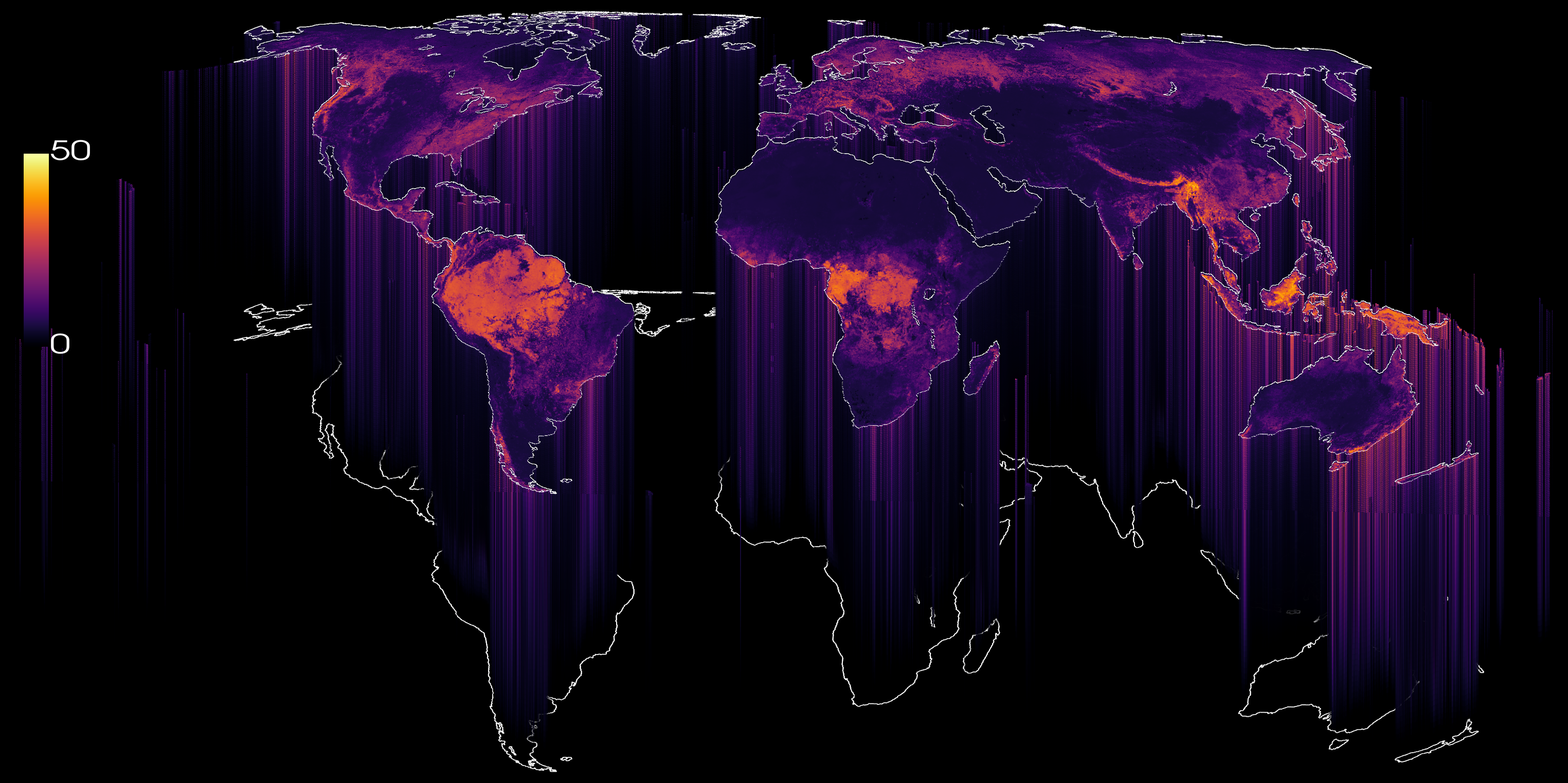
The VSM brings a vertical dimension to global vegetation mapping, extending beyond canopy height to characterzing vegetation structure at 10 m resolution. Trained with 178 million sparse GEDI lidar observations, a deep learning model translates Sentinel-2 imagery into continuous maps of 101 relative height metrics (RH0–RH100), each with predictive quantiles that describe its uncertainty. By capturing vegetation structure beyond canopy height, VSM supports applications in forest monitoring, biodiversity assessment, and ecosystem research.
Explore
- 📄 Preprint: eartharxiv.org/repository/view/15380
- 🗺️ Interactive map: huizhml.github.io/map-explorer
- 💻 Code: github.com/huizhml/global-vegetation-structure
- 📦 Storage:
s3://geoai-ucph/gvsm/on the endpointhttps://data.source.coop
Key facts
What is an RH metric?
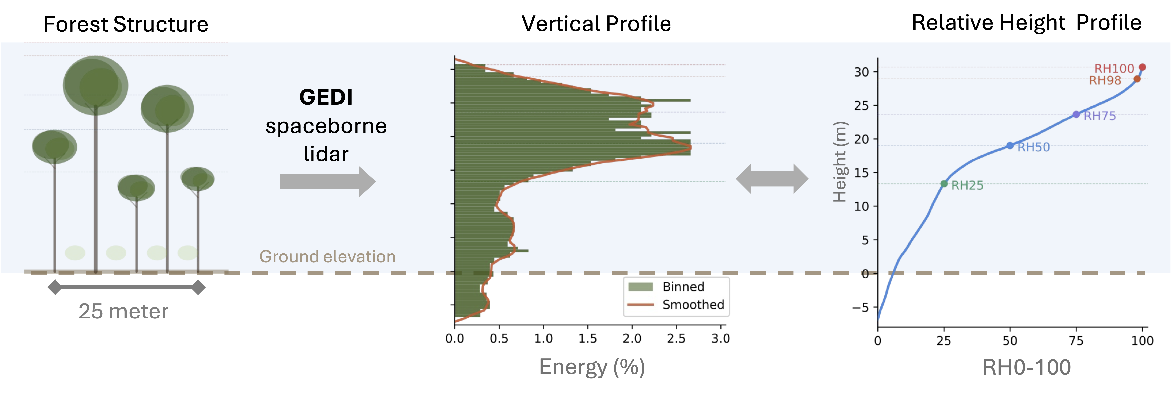
GEDI records laser energy reflected by vegetation and the ground within each footprint. RHn is the height above ground below which n % of that returned energy has accumulated.
- RH98–RH100: approximate canopy top height, comparable to conventional canopy height products.
- RH50: the height below which half of the total returned energy has accumulated.
- Low RHs (RH0–RH25): describe the lower portion of the cumulative return, influenced by both vegetation and ground returns.
Taken together, RH0 … RH100 for a pixel make a cumulative vertical profile. You can use it to study canopy layering, understory density and structural diversity, not only the top height.
Data organization
File names follow RH{level}_Q{quantile}.tif, with level from 0 to 100 and quantile from 0 to 2.
To find the tile that covers your area, use the Sentinel-2 MGRS tiling grid. Neighbouring tiles overlap by about 10 km.
Quantiles: Q0, Q1, Q2
The model is trained with quantile regression, so each RH level is predicted at three quantiles:
Q0 and Q2 together give a 90 % prediction interval for each pixel and RH level. The interval is calibrated with conformal prediction, so it reaches the target coverage against held-out GEDI data. The interval width (Q0 − Q2) is a simple per-pixel uncertainty measure.
Note: Only
Q1(the median) is published at the moment.Q0andQ2will be uploaded to the same folders soon.
Pixel values
- Data type
Int16. Values are in decimetres: divide by 10 to get metres. - NoData =
32767. This marks pixels without a valid prediction, such as water, snow and ice, persistent cloud. - Low RH levels can be negative. This follows the GEDI convention: the lowest part of the return waveform lies below the detected ground elevation.
Quick start
GDAL: inspect a file over HTTP without downloading it:
Python: read the vertical profile at a point:
AWS CLI: list or download data:
The COGs also open directly in QGIS (Layer → Add Raster Layer → Protocol: HTTP(S)) and in rioxarray/xarray.
Caveats
- These are model predictions, not lidar measurements. Accuracy varies with biome, terrain slope and canopy density. In dense tall forests, predicted heights tend to be biased toward the mean.
- GEDI only samples between about 51.6° N and 51.6° S. Predictions further north and south rely on the model extrapolating beyond its training data, so treat them with extra caution.
- RH metrics are not the same as airborne-lidar canopy height. GEDI's RH metrics come from a ~25 m footprint waveform. They are related to, but not identical to, canopy height models derived from airborne laser scanning (ALS).
- Each year's map is built from Sentinel-2 imagery of that year. Differences between years mix real change with differences in the input imagery, so change analysis needs care.
- The global mosaics are 10 m predictions averaged to ~1 km. They smooth out fine-scale structure, so use the 10 m tiles for quantitative work.
License
Creative Commons Attribution 4.0 International (CC BY 4.0)
Citation
Zhang, Hui, Nico Lang, Mikolaj Mazurczyk, Stefan Oehmcke, Ke Huang, Martin Brandt, Rasmus Fensholt, Ankit Kariryaa, and Christian Igel. "A vertical vegetation structure model of the Earth." EarthArXiv preprint (2026). https://doi.org/10.31223/X5M22F
Contact
Managed by GeoAI@UCPH, University of Copenhagen.
Hui Zhang (huzh@di.ku.dk) · Nico Lang (nila@di.ku.dk) · Christian Igel (igel@di.ku.dk)